

Kimberley Project
The Kimberley Project comprises of 2 sub-projects in the Kimberley region of Western Australia named Ruby Plains and Copper Flats.
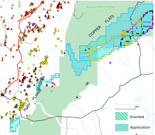
Figure 12 Kimberley Project – Location on DMPE Basemap with mineral occurrences and Prospect Areas
Key to overlapping applications 5247 cyan 5820 black 5821 Tan
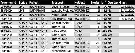
Table of Leases and areas
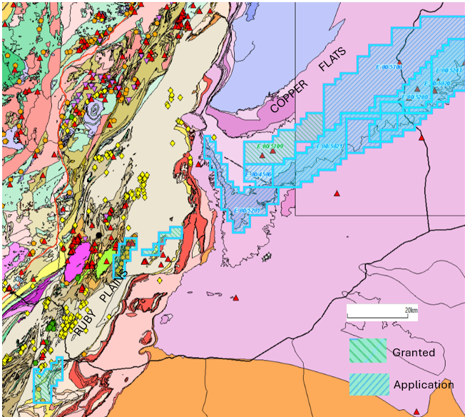
Figure 14 Kimberley Project – Leases on Bedrock Geology
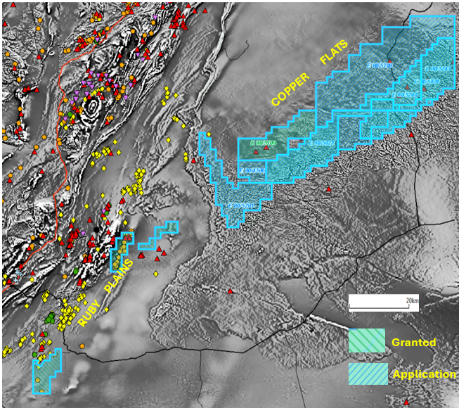
Figure 15 Kimberley Project – Leases on 1VD Magnetics
Copper Flats Area
The Copper Flats area is comprised of one granted EL80/5709 and eight exploration licence applications (ELA 80/4569, 4586, 5247, 5280, 5281, 5708, 5820 and 5821) covering some 400 blocks or approximately 1,000 km2 and is centred approximately 125km east-northeast of Halls Creek, and 215km south of Kununurra.
The project area comprises Ord Basin sediments and volcanic within the Hardman Syncline (see Figure 4.10). The Copper Flats area has been explored since the 1970s, with numerous reports of visible copper mineralisation in outcrop. Previous exploration includes rock chip and channel sampling along with RC drilling.
The Copper Flats is an early-stage exploration area with excellent first pass results. Past exploration has identified areas of strong geochemical anomalism in favourable structural settings. The interpretation of drilling and mapping suggests that the copper mineralisation at Copper Flats is both a lateral stratabound mineralisation and a vertical narrow structurally controlled mineralisation (see Figure 4.11).
Previous Exploration
The Copper Flats area has been explored since the 1970s, with numerous reports of visible copper mineralisation in outcrop. Ord River Resources Limited (Ord) completed a small rock chip and channel sampling program on the Copper Flats project area. Sampling over the Project area has returned encouraging results, including:
Channel Sample of 15m @ 8% Cu & 18g/t Ag
Channel Sample of 5m @ 6.4% Cu & 129g/t Ag
Channel Sample of 0.5m @ 15.8% Cu
Channel Sample of 9m @ 7.2% Cu & 174g/t Ag
Channel Sample of 16m @ 7.8% Cu.
A 54 RC drill hole program was completed by Ord River Resources Limited during the 2006-2011 period. Significant intercepts include:
RC Hole CF07RC005 – 8m @ 1.65% Cu from surface including 1m @ 5.06% Cu
RC Hole CF07RC028 – 7m @ 1.53% Cu from surface & 2m @ 1.07% Cu from 14m
RC Hole CF07RC035 -1m@ 3.1% Cu from 2m
RC Hole CF07RC041 – 2m @ 2.5% Cu from 8m &10m @ 0.65% Cu from 25m Including 1m @ 4.96% Cu.
Limited exploration has been undertaken on the project since 2011.
Exploration Potential
The Copper Flats Sub-Project is an early-stage exploration project with excellent first pass results. Past exploration including trenching and surface geochemistry has identified areas of strong geochemical anomalism in favourable structural settings.
The interpretation of drilling and mapping suggests that the copper mineralisation at Copper Flats is both a lateral stratabound mineralisation and a vertical narrow structurally controlled mineralisation. It is suggested to review geophysical data and define appropriate tests for areas of known surface mineralisation, in particular for deeper sulphide mineralisation. Past explorers have proposed airborne electromagnetic (EM) as an effective method of ranking the large number of surface targets that have been generated from past work. In addition to EM, better quality/detailed aeromagnetic data may assist in defining regional structures which are associated with the copper mineralisation at Copper Flats project area.
Figure 13 Copper Flats Area – Geology (with GSWA 1:100,000 geology)
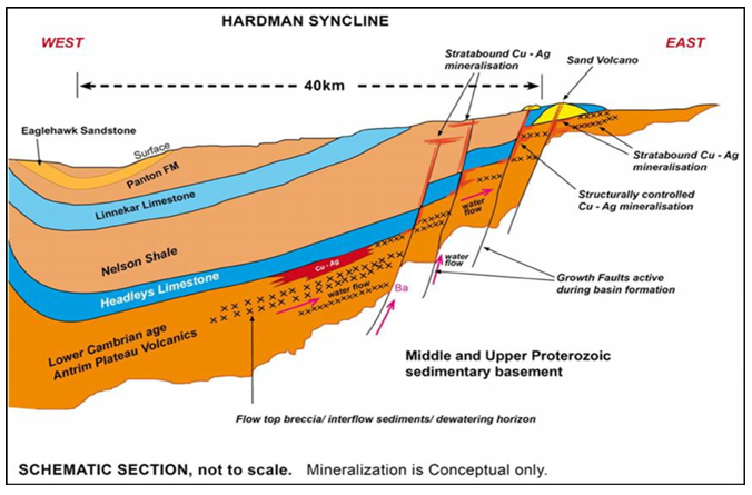
Figure 14 Copper Flats Area – Conceptual Mineralisation Model
Ruby Plains Area
Leases
The Ruby Plains area is comprised of four granted exploration licences (E80/5079, E80/5232, E80/5409 and E80/5411) and three exploration licence applications (ELA 80/5085, 5086 & 5519) covering 287 blocks or approximately 860km2. The project is located approximately 50km from Halls Creek. The area is located within the Halls Creek Orogenic Belt, one of the principal tectonic elements of the Kimberley Region. Cobalt (Co)-manganese (Mn) mineralisation is present in the Ruby Plains Group, which is the main stratigraphic unit in the area. Historical exploration across the project area has focussed predominantly on Mn mineralisation (with associated Co mineralisation) with mapping, magnetic surveys, rock chip sampling and drilling. The Ruby Plains Sub-Project is an early-stage exploration project. Cobalt, Manganese and copper prospectivity of the area has been well established by past explorers.
Previous Exploration
Historical exploration completed to date across the project area has focussed predominantly on manganese (Mn) and Cobalt (Co) mineralisation. Exploration activities completed includes:
- Detailed geological mapping
- Rock chip sampling with
- Cobalt (Co) results ranging up to 9,370ppm Co;
- Significant Mn in Rock Chips including 35 samples >30% Mn with the highest result of 55.8%; Mn and
- Coincident Copper Cobalt and Nickel rock chip sample result up to 0.7% Cu, 0.65% Co and 0.33% Ni.
Scout drilling. Significant results include:
- SCR013 10m @ 1,930 ppm Co from 5m
- 09RPR024 10m @ 2,552 ppm Co from 3m.
The activities completed have returned significant cobalt mineralisation associated with manganese. Cobalt mineralisation is to be used as a vector for nickel and copper mineralisation. Figure 4:12 shows the location and Cobalt results from the rock chip sampling.
Exploration Potential
The Ruby Plains Sub-Project is an early-stage exploration project. Cobalt, Manganese and copper prospectivity of the area has been well established by past explorers.
The Project had the potential for cobalt-manganese and Nickel – Copper – Cobalt deposits. A detailed geological mapping, rock chip sampling and scout drilling are proposed to refine the understanding of the controls on, and extents of, mineralisation, and geological targets. A scout drilling program can test the depth potential of any identified mineralisation. Based on positive results being received from the initial scout phase of drilling, a systematic pattern drilling program is suggested.
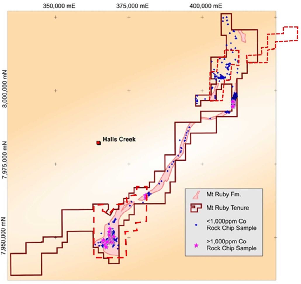
Figure 15 Ruby Plains Project – Prospective Formation & Rock Chip Sampling with current leases in red dash

FOLLOW US

