Canary Project
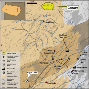
The Canary project consists of two mineral dispositions covering an area of 73 km² and is located 11 km directly north of IsoEnergy Ltd’s (TSX.V:ISO) Hurricane (see Figure 1) deposit (48.61 million lbs of U₃O₈ based on 63,800 tonnes grading 34.5% U₃O₈). 1 Historical drilling on the project identified anomalous uranium, which, together with recently defined geophysical anomalies, suggests the Project is highly prospective for both unconformity-style and basement-hosted uranium mineralisation.
Exploration work by Standard Uranium Ltd (TSX.V:STND) (‘Standard Uranium’), the parent company of the vendor of the Project, has identified a range of high-priority drill targets2 that Mamba intends to test in early / mid 2024. Based on historical drilling, the Athabasca-basement unconformity has been intersected between 84 and 230 meters from the surface on the project, resulting in shallow drill target depths. Additionally, of the three major conductive trends on the Project, only one has been adequately drill tested, and elevated uranium was intersected.
Location
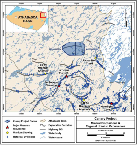
The Canary Project is situated in northeastern Saskatchewan, approximately 96km southeast of the community of Stony Rapids and about 748km north-northeast of Saskatoon, the largest city in Saskatchewan.
The Canary Project consists of two mineral dispositions totalling 73km². The dispositions are currently held 100% by Standard Uranium (Saskatchewan) Ltd., a wholly owned subsidiary of Standard Uranium Ltd.
The Project is accessible year-round by helicopter, float- or ski-equipped aircraft. The nearest airbase is Points North Landing, approximately 52 km southeast of the Project, with near-daily commercial flights. Points North Landing also possesses a water aerodrome allowing for floatplane access proximal to the Project. This airbase can be reached in approximately 15 minutes from the Project.
Figure 1: Canary Uranium Regional Location Map
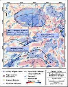
Figure 2: Canary Project in context of known uranium deposits/showings and background first vertical derivative magnetics.
Geology
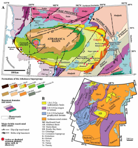
The Canary Project lies within the Hearne Subprovince of the northeastern Saskatchewan. The Hearne Sub-province contains crystalline basement rocks of the lithostructural Mudjatik Domain, characterised by a dome and basin structural style comprising concentric domes of Archean granitoid orthogneiss separated by discontinuous Paleoproterozoic supracrustal rocks of the Wollaston Supergroup and overlain by Paleo to Mesoproterozoic sandstones of the Athabasca Supergroup.
Historical exploration efforts have detected multiple electromagnetic (‘EM’) anomalies correlating to zones of generally east-west trending conductive metasedimentary rocks on the Project. Major structural features such as faults and lithological contacts coincident with conductive packages have also been intersected along with corresponding increases in alteration intensities.
Dominant alteration types observed in the Mudjatik and Wollaston rocks on the Project include sargillisation and hydrothermal hematite-chlorite alteration associated with a paleo weathering profile and concentrated along structures. Graphite and pyrite mineralisation are common within metasedimentary rock packages. Alteration intensity is strongly associated with the unconformity contact with the overlying Athabasca Supergroup.
Historical Exploration
Numerous uranium exploration methods have been employed since the late 1960s, encompassing prospecting, soil sampling, ground electromagnetics, seismic studies, geological mapping, drilling, geochemical sampling of lakes and streams, as well as airborne magnetic and electromagnetic surveys, along with canoe reconnaissance.
Historical airborne electromagnetic work completed between 1993 and 2006 identified three main conductive systems that are thought to represent trends of structurally disrupted graphitic metasedimentary rocks.
Historical drill-hole CRK-137 (Cogema, 1996) returned highly anomalous uranium near the unconformity with 10 ppm uranium over 7.4 metres in systematic composite sampling of the sandstone, and strong hydrothermal alteration observed throughout the interval. Within this zone and directly above the unconformity, a discrete 0.5 m interval returned 103.1 ppm uranium. Directly below the unconformity, a 0.5 m interval sample returned 250 ppm uranium.
Along the same trend, drill-hole HL-07-03 (Denison, 2007) returned elevated uranium up to 3.3 ppm over 20.6 m in the sandstone, though the conductor was not intersected, and this target zone has not been adequately drill-tested.
Figure 3. A) Lithostructural domains of the Churchill structural province and regional Athabasca Basin geology in northern Saskatchewan and Alberta. The Canary Project is shown in blue. B) Cratonic map of western Laurentia showing Fig. 3A (dashed box) in context of continent-scale tectonics. (Modified from Hillacre et al., 2021).
Figure 4: Project Location Map
Further Details – 🔗Canary Uranium – Athabasca Basin, Canada


